 Southwest
Environmental LimitedSouthwest
Environmental Limited
Southwest
Environmental LimitedSouthwest
Environmental Limited| London |
| 02076 920 670 |
| Exeter |
| 01392 927 961 |
| Manchester |
| 01612 970 026 |
| Bristol |
| 01173 270 092 |
A model is a mathematical way of try to mimic real life events, or sometimes future events. With Flood Zone Modelling we try to predict which areas of land will flood given a set of climatic events. We then end up with a set of risk values (1 in 10 year) for example and we can create areas (zones) on a map for each risk level.
Described simply in a flood zone modeling exercise we mix land and
weather mathematically and try to present the results clearly.
Inland areas are the simplest to describe as they are not influenced by
tides and storm surge, which complicate costal modeling runs.
Considering our simplified area, we "dump" a certain amount of rain on a
given land area. The land is not perfectly flat and so certain bits
"fill up" more quickly and more deeply than others, and in this way we
can start to produce a flood risk zone map.
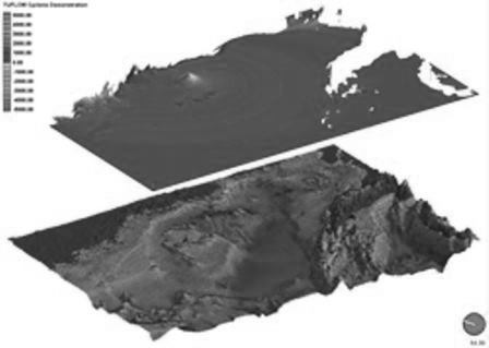
 The overly the right shows flood zones overlain on to satellite imagery.
This is useful in countries where there is poor map coverage, but in the
UK we would typically use ordnance survey mapping.
The overly the right shows flood zones overlain on to satellite imagery.
This is useful in countries where there is poor map coverage, but in the
UK we would typically use ordnance survey mapping.
Bespoke flood modeling has become very common in the UK, as most the the
flood data available from commercial and government sources does not
account for climate change, and as such may be inaccurate.
.jpg)
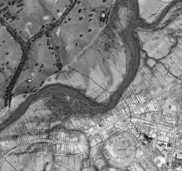
The image to the left shows how the model use points to create a cloud
of data point within a model. The layers is carried out at various
points, and the results combined to create surfaces.
To run a model over a very large area requires a powerful computer,
however recently you can rent space on a ready made computer which helps
with costs if we have to undertake large modeling exercise,
Amazon Web Services is one such
service provider, although in the winter we like to try and run the
model in the office to make use of the waste heat from the computer
processors which is considerable!.jpg)
Using the model we can also create exceedance flow routes, water
velocity, hazard, depth and all manner of mapping.
As previously mentioned flood zone modeling is complicated in coastal
regions as we have to account for tidal and storm surge influences
within the model.
The cost of bespoke flood zone modeling starts at around £2000 + VAT and this would rely on to reuse of pre-existing flood data which we use to populate the model and then re-run to add in climate change allowances.
The below section was written by a machine.
Flood zone modelling represents a significant technical step beyond standard risk mapping. While general mapping relies on existing Environment Agency data, bespoke modelling utilizes specialized software like TuFlow or ISIS to perform computerized calculations that simulate real-world water behavior across a specific site. This is often the only route to challenging inaccurate flood designations or proving a site's safety for essential infrastructure.
Our team provides high-level hydraulic analysis to support complex Flood Risk Assessments (FRA). These models are critical for quantifying specific risks that general data may overlook:
Detailed modelling is typically required for large-scale housing developments or projects where off-site flood risk might be increased. Our approach follows the latest national standards to ensure regulatory acceptance:
Southwest Environmental Limited has been delivering technical evidence for 15 years, with over 900 projects completed across the UK. By combining hydraulic modelling with expertise in Environmental Impact Assessments (EIA), we provide a robust route to planning approval. Our consultants hold the professional credentials (IES, IAQM) required to negotiate directly with lead local flood authorities and the Environment Agency. Whether you need to simulate surface water runoff or verify finished floor levels, our models provide the clarity required for complex developments.